Property Record
Russell Pkwy, Warner Robins, GA 31088
NEARBY LISTINGS FOR SALE OR LEASE
Property Detail
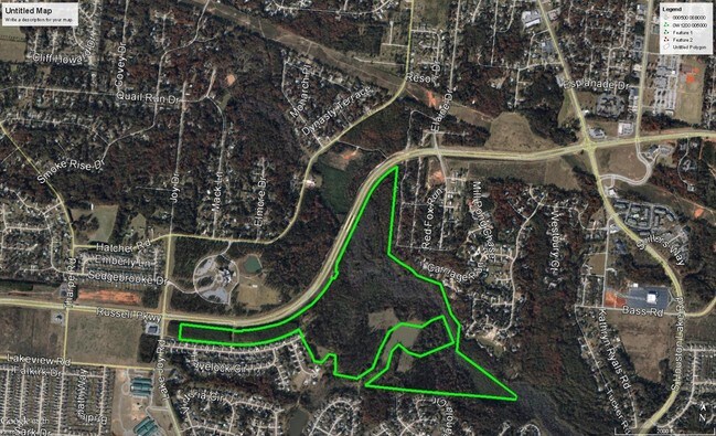
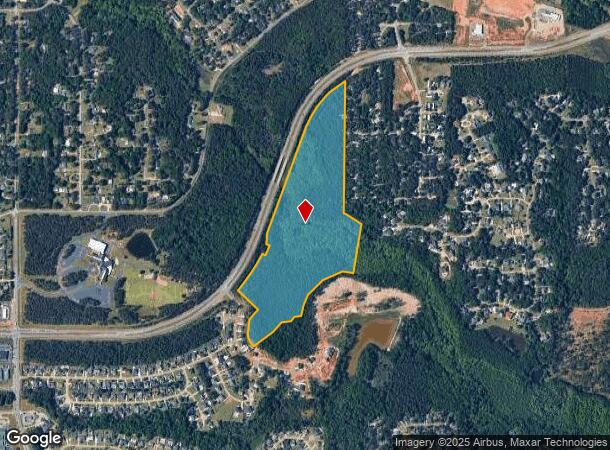
Russell Pkwy
Warner Robins, GA
10Th Land District
0W1200005000
58.36 ACRES PARCEL A4
Residentialacreage
Houston
A
Georgia
13225C0150C
58.36 AC
2024
Perry/Warner Robins
2024
Other Market Areas
021119
DEMOGRAPHICS near Russell Pkwy
1 Mile
3 Mile
5 Mile
2024 Total Population
4,257
55,203
117,189
2029 Population
4,610
60,142
127,887
Pop Growth 2024-2029
+ 8.29%
+ 8.95%
+ 9.13%
Average Age
40
37
38
2024 Total Households
1,568
21,698
45,287
HH Growth 2024-2029
+ 8.16%
+ 8.83%
+ 8.94%
Median Household Inc
$109,003
$80,490
$73,064
Avg Household Size
2.60
2.50
2.50
2024 Avg HH Vehicles
2.00
2.00
2.00
Median Home Value
$192,390
$173,585
$165,543
Median Year Built
1996
1996
1992
Nearby Places
Map Layers
Map Styles
 Street
 Aerial
- Restaurants
- Banks
- Shops
- Fitness
- Groceries
SALE & LEASE HISTORY
LISTING DATE
SALE/LEASE

Jul 28, 2017
For Sale
Nearby Properties
Address
Land Use
TOTAL SIZE
Lot Size
Zoning
Address
Land Use
TOTAL SIZE
Lot Size
Zoning
27,504 SF
26.31 AC
PUD
Address
Land Use
TOTAL SIZE
Lot Size
Zoning
80,000 SF
46.13 AC
R2
Address
Land Use
TOTAL SIZE
Lot Size
Zoning
15,006 SF
30.30 AC
R4
Address
Land Use
TOTAL SIZE
Lot Size
Zoning
5,400 SF
22.93 AC
R4
Address
Land Use
TOTAL SIZE
Lot Size
Zoning
5,648 SF
49.72 AC
R4
Address
Land Use
TOTAL SIZE
Lot Size
Zoning
9,828 SF
18.63 AC
R4
Address
Land Use
TOTAL SIZE
Lot Size
Zoning
5,440 SF
36.50 AC
R4
Address
Land Use
TOTAL SIZE
Lot Size
Zoning
14,754 SF
24 AC
C2
Address
Land Use
TOTAL SIZE
Lot Size
Zoning
15,006 SF
28 AC
PDE
Address
Land Use
TOTAL SIZE
Lot Size
Zoning
10,568 SF
35.44 AC
R4
Address
Land Use
TOTAL SIZE
Lot Size
Zoning
26,271 SF
17.43 AC
C2
Address
Land Use
TOTAL SIZE
Lot Size
Zoning
7,172 SF
24.73 AC
R4
Address
Land Use
TOTAL SIZE
Lot Size
Zoning
226,032 SF
49.90 AC
C2
Address
Land Use
TOTAL SIZE
Lot Size
Zoning
11,056 SF
17.41 AC
R4
Address
Land Use
TOTAL SIZE
Lot Size
Zoning
273,000 SF
63.42 AC
C2
Address
Land Use
TOTAL SIZE
Lot Size
Zoning
301,206 SF
19.79 AC
C2
Address
Land Use
TOTAL SIZE
Lot Size
Zoning
219,205 SF
26.17 AC
R2
Address
Land Use
TOTAL SIZE
Lot Size
Zoning
112,824 SF
13.07 AC
C2
Address
Land Use
TOTAL SIZE
Lot Size
Zoning
112,824 SF
Address
Land Use
TOTAL SIZE
Lot Size
Zoning
112,824 SF
Address
Land Use
TOTAL SIZE
Lot Size
Zoning
338,708 SF
28.28 AC
M-2
Address
Land Use
TOTAL SIZE
Lot Size
Zoning
18,954 SF
20 AC
C2
Address
Land Use
TOTAL SIZE
Lot Size
Zoning
28,668 SF
17.38 AC
R4 C2
Address
Land Use
TOTAL SIZE
Lot Size
Zoning
92,930 SF
18.66 AC
C2
Address
Land Use
TOTAL SIZE
Lot Size
Zoning
21,750 SF
11.48 AC
C2
Address
Land Use
TOTAL SIZE
Lot Size
Zoning
16,570 SF
15.62 AC
R4
Address
Land Use
TOTAL SIZE
Lot Size
Zoning
63,274 SF
40.80 AC
C-2, WR
Address
Land Use
TOTAL SIZE
Lot Size
Zoning
67,732 SF
25 AC
R4
Address
Land Use
TOTAL SIZE
Lot Size
Zoning
223,608 SF
22.40 AC
C2
Address
Land Use
TOTAL SIZE
Lot Size
Zoning
76,751 SF
26.32 AC
R1
The World's #1 Commercial Real Estate Marketplace
Connect with us
© 2025 CoStar Group
The information above has been obtained from sources believed reliable. While we do not doubt its accuracy we have not verified it and make no guarantee, warranty or representation about it. It is your responsibility to independently confirm its accuracy and completeness. Any projections, opinions, assumptions, or estimates used are for example only and do not represent the current or future performance of the property. The value of this transaction to you depends on tax and other factors which should be evaluated by your tax, financial, and legal advisors. You and your advisors should conduct a careful, independent investigation of the property to determine to your satisfaction the suitability of the property for your needs.